Contributors
Aviation Museum (Bucharest)
Dimitrie Gusti National Village Museum (Bucharest)
Teleorman County Museum (Alexandria)
Boian Plain Museum (Drăgănești-Olt)
Ostrovit S.A.
Caro Hotel
Aerial Archaeology. In Romania and in Europe
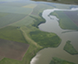
Using satellite images to identify archaeological structures in the Banat Region, SW Romania
Dorel Micle & Alli
Automatic identification methods of linear and circular archaeological structures via satellite imagery processing
Dorel Micle, Daniela Zaharie, Oana Borlea
Abstract
Department of History, West University of Timisoara, Romania
dmicle@litere.uvt.ro
Department of Computer Science, West University of Timisoara, Romania
dzaharie@info.uvt.ro
Student, Department of History, West University of Timisoara, Romania
Very wide spaces, rough terrain or the lack of visual perspective are the most invoked motives because of which wide areas of a country’s territory are not archaeologically investigated, thus creating a multitude of archaeological white spots.
The usage of satellite images to identify archaeological sites represents a common practice of this scientific community nowadays, and, more and more often, the problem of automatic processing appears, of finding new methods and techniques of automatic identification of archaeological structures through satellite imagery processing.
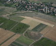
Finding the best solutions means to eliminate modern structures and study only the historic ones during the process. Benefitting of an almost total coverage with very good quality satellite images offered by Google Earth of the Timis County (Romania), and also of the richness and variety of noticeable archaeological sites on these images, our team tried to identify some work patterns which are accessible to archaeologists.
Remote sensing techniques proved to be useful in non-intrusive investigation of archaeological sites by providing information on buried archaeological remains. The presence of different remains in the ground can generate different marks identifiable in high resolution panchromatic and/or multispectral images: crop marks, soil marks, shadow marks and damp marks.
Automatic identification of archaeological sites from digital images is a difficult task, since the small anomalies induced by the buried remains are usually hidden by stronger marks corresponding to the structures currently existing on the ground (roads, constructions, trees, rocks etc). Therefore the final identification and interpretation of the marks should be made by the expert by visually inspecting the enhanced image and by corroborating his observations with additional information (e.g. historical maps, current roads network etc).
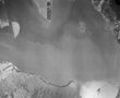
In order to prepare the image for visual inspection we first applied a flow of basic image processing operations: gray scale conversion, histogram equalization, edge detection (Sobel filter), thresholding, inversion and erosion. Having the aim of developing a semi-automatic tool for identification of linear and circular shapes we also investigated some more sophisticated operations. One of these operations is the Hough transform which we applied in order to identify linear structures (e.g. wave like roman fortifications) and circular structures (e.g. burial mounds).
The main problem we encountered in identifying the ancient marks is the fact that they are somewhat obscured by the marks of current land division, roads, contemporary buildings etc. In order to deal with this problem we applied both a supplementary pre-processing and a post-processing step. As pre-processing operation we used the singular value decomposition of the image. By ignoring the components corresponding to the highest singular value(s) (which contain the most important features in the image) we obtained an image where the ancient marks are more visible. In the post-processing step we tried to eliminate the lines detected by the Hough transform which correspond to the current land division by using the remark that this lines are mainly parallel while the ancient mark (e.g. a linear fortification) has a different orientation. Using such operations we successfully identified the location of a linear „roman“ fortification.
The perspectives appear to be promising, so we also want to identify work methods for automatic identification of irregular structures and colors.
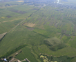
The Linear Earthworks System in Timis County (S-W Romania, Banat region). A Synchronic Approach
Department of History, West University of Timisoara, Romania
dmicle@litere.uvt.ro, lmaruia@litere.uvt.ro, acintar@litere.uvt.ro, ctimoc@litere.uvt.ro
Department of Geography, West University of Timisoara, Romania
torok@cbg.uvt.ro
Student, Department of History, West University of Timisoara, Romania
Timis County, part of the historic region of Banat, situated in south-western Romania, is traversed from north to south by a system of three linear defense works, constituted by a number of successive ditches and earthworks, known to specialists as „roman earthworks” they have not been dated or ethnically assigned. Having been confronted with this on field, out team has tried during the past two years, through modern techniques and methods, to establish the exact route these defense works follow and to identify their common characteristics, both as far as defense is concerned as well as method of construction and establishing the relationship with the geographic environment. Our research combines methods of geophysical prospecting (magnetic surveying) with topography and archaeological mapping, as well as the processing of satellite imaging, in order to compile an interdisciplinary study of landscape archaeology. Our main objectives were to identify the route of the linear defense works and its features and the relation between the fortifications and landscape.
The research had two parts: 1. field work (archaeological field research, geo-morphologic analysis, archaeological topography, and geo-physical prospecting – magnetometry; 2. laboratory work (the analysis of: topographical and cadastral maps, satellite images, GIS processing).
The final results were the creation of maps with the exact path of the linear fortifications, the identification of construction features, the identification of landscape geo-morphological features on the route of the fortifications using satellite images.
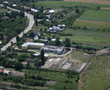
Using satellite images to identify a possible medieval road in the Vinga High Plains (Banat, România)
Dorel Micle, Leonard Dorogostaisky, Liviu Măruia, Marcel Torok, Adrian Cîntar, Lavinia Bolcu
Department of History, West University of Timisoara, Romania
dmicle@litere.uvt.ro, lmaruia@litere.uvt.ro, acintar@litere.uvt.ro
Alcatel-Lucent Romania
leonard.dorogostaisky@alcatel-lucent.ro
Department of Geography, West University of Timisoara, Romania
torok@cbg.uvt.ro
Student, Department of History, West University of Timisoara, Romania
Our study started with an analyze of satellite images provided by Google Earth on a South – North sector between Beregsău Brook (Nerad, Bega Veche) which flows North of Timişoara and Mureş River as we noticed the trajectory of a possible earth road, not yet archaeologically investigated, and also the presence of two square brick fortifications, quite similar in shape and defensive system, which chronologically fit between the XVIth and the XVIIth century (based on the ceramic materials gathered). One of the fortifications was identified West of the present day village Frumuşeni, Arad County, on the South shore of Mureş River, and the second one is East of present day locality Sânandrei, Timiş County, on the North shore of Nerad Brook.
Our team’s goal was to certify the presence of this medieval road by studying the available documentary material (written medieval sources, military topographical maps, orthophotograms and satellite images, old historic maps, etc.) but also by field probation through systematic surveys and punctual geophysical prospections, as we tried to identify the route and structure of this road.
Placed in a larger landscape archaeology research, this study can bring multiple information related to economical, political and military context in which the medieval road functioned, and also the possible connection between the two fortifications mentioned above. Also, a medieval rural habitat sectioned by the trajectory of this road analysis can bring out characteristic elements of a stabile and controlled transportation route (post stations, etc.) which can improve historical data related to this period.
Our procedure is a technical one, which is based on new documentation means and methods that contribute to the improving of knowledge related to a less studied period – the one regarding the Turkish occupation of the Banat region – through highlighting elements of military architecture (fortifications) and infrastructure (roads).